
Lurgan Students Showcase Cross-community Project at World’s Largest Digital Mapping Conference
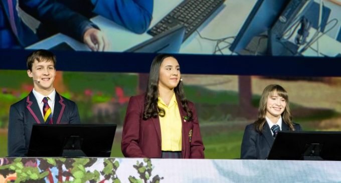
Esri Ireland, the market leader in geographic information services, has announced that three schools from Lurgan, County Armagh, presented a cross-community project to 19,000 attendees as part of the opening session to Esri’s International User Conference in San Diego. The pupils became the first students from outside of the USA to present on the main stage in the conference’s 39-year history.
Students from Lurgan College, St. Ronan’s College and Lurgan Junior High School, showcased their Shared Education Project, which brought together Catholic and Protestant students to map and analyse sectarian divisions in Lurgan, while working together to bring about positive change in their communities.
Held in the San Diego Convention Centre, the week-long event is the world’s largest Geographic Information Systems (GIS) conference. It gathers users, experts, scientists, educators and decision makers from every discipline – including commercial businesses, governments and non-profits – from 128 countries, interested in how GIS can transform their work, organisations, communities and countries.
The Lurgan Shared Education Project was chosen ahead of thousands of other school projects from around the world for its demonstration of how digital mapping technology can be used to promote peace. In addition to the main stage presentation, the performance was livestreamed to thousands of geography enthusiasts across the globe.
Three students, three teachers and a member of the PSNI travelled to San Diego to present alongside world-renowned speakers, such as Jane Goodall and E.O. Wilson – who discussed the importance of biodiversity conservation – and Jack Dangermond, president and founder of Esri.
Alistair Hamill, head of geography, Lurgan College, said: “It is an incredible honour to have been chosen by Esri to travel to the US and present in front of such an engaged and global audience. The students are an inspiration and this has been a life-changing experience for them. As well as presenting at this prestigious event, through the project they have increased their understanding of their town and each other – forming lifelong bonds with new friends. They have also shown the power of collaboration and demonstrated the possibility of a more peaceful and inclusive future.”
Lurgan is a very spatially divided town – residential areas tend to be segregated and public spaces are often underused, especially at night. Students from the three schools came together and visited locations across both sides of the community in Lurgan, recording their perception of safety within that space using Esri’s mobile apps. With the aid of their teachers and Esri Ireland’s ArcGIS for Schools team, students then used Esri’s ArcGIS online mapping platform to analyse the data.
The survey showed that sectarian divides still exist in the town, highlighting locations that certain students rarely or never visit and others which they feel uncomfortable and unsafe in. The students then discussed the reasons behind the findings as well as ideas to reduce divisions in Lurgan. These insights were shared with the PSNI, the local council and the community relations council.
Joanne McLaughlin, ArcGIS for Schools business sponsor, Esri Ireland, explained: “This cross-community initiative gave students a platform to put forward suggestions to make Lurgan a more inclusive place. It has made a real difference in Lurgan with stakeholder groups in the community acting on findings from the survey. Esri Ireland recently made our digital mapping software freely available to every school on the island of Ireland and it is fantastic to see such an impactful use of GIS. This is a shining example of how technology can enable young people to become powerful agents for positive social change in their community.”
Commenting on the Lurgan presentation, Jack Dangermond, founder and president, Esri, said: “It is truly inspiring to see these young people collaborate using GIS to tackle deeply rooted issues in their community. They are the next generation of decision makers, and they show us new ways of thinking about old problems by demonstrating the capability of technology, geography, and innovation to solve future challenges.”
CAPTION:
Pictured presenting their cross-community project on the main stage at the Esri International User Conference in San Diego are (L-R): Leon Van Der Westhuizen, Lurgan Junior High School; Aiesha Mouhsine, St. Ronan’s College; and Hannah Trew, Lurgan College.


